Thursday Jun 13 2013
Black Canyon, day 2
This area was in the making for
billions of years. With some volcano
activity and the extreme power of the
water and gravity in the last million years
you get the black canyon.
And then came the 'white' people.
First major accomplishment,
the Denver and Rio Grande Rail Road
along the bedding of the Gunnison,
from 1882 to 1951. To transport million
tons of natural resources.
Later, shortly converted to a touristic road.
In 1960 they started building dams.
Now there are 3 dams on the Gunnison river
- the blue mesa dam
- the morrow point dam
- the crystal dam
Recreation, agriculture, drinking water,
power generation...
The reservoirs nearly stops the ultra fast
flowing of the river.
Anyhow, the last 50 years quite changed
the bigger picture. The powerful multi use
of the land.
And probably there is still not enough water to
keep to keep the front yards green in Denver.
Water politics to the max.
And only the beginning ?
Still enjoyed much of the powerful
rock formations. The rock, as symbol
for the Denver and Rio Grande Rail
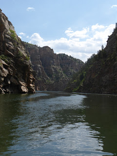
Road. A picture from down on the water.
The rock from up on the rim.
On the hike down, along the Curecanti creek
from the rim to the Gunnison river (sorry
the reservoir, now 100 ft above the
original bedding). 4 miles and 900 ft drop.
This was a beautiful and rather easy hike.


No comments:
Post a Comment