Thu Apr 25 2013
Found the lost Canyon.
After a dry night (except the secret duvel)
went on in search of the Needles national park.
After passing the 1000 years old newspaper,
learned that the campground was full, again.
Reason, it is really spring, the first week
that the weather is perfect. I agree.
Found a perfect camping ground, a few minutes
away, even with a trading post (see later).
While reading the Rock-in-the-wall, I wanted
the try the expedition to the Lost Canyon.
Some difference: I got a map, GPS, and somewhat
marked trail. But even now, in this terrain
reading the mountain is so extremely difficult.
Knowing what is behind the next rock, is it feasible
to go up or down ? Many times I had to backtrack
just to find a possible route.
Yes, that is how it started.
On top of the first Canyon. Find your way down,
cross the canyon, go up into the next Canyon.
The next Canyon, a little steeper, to go all the way down.
See the small cairns (small pile of rocks as markers) to find
roughly your path
After 4 or 5 of these canyons, each 2 or 3 miles,
found the little lost Canyon, with plenty of water
for your horse.
Only it's completely impossible to pass these
steep up and down rocks with a horse.
Now, only find your way out, next to the cliff.
This was the only place with a small ladder.
The rest was all up to your "reading the mountain"
Another day with a 15 mile expedition.
Small, but needed to find the park, the camping
ground, and enjoy the rest of the evening.
After the hike, on the way home, stopped in the
trading post and found the "WYLD", brewed by
"UINTA", in Salt Lake City, Extra Pale Ale,
Earth, Wind and Beer.
Perfect for watching the sunset over the Needles.
Really, no plans at all. But please post a comment or suggestion where I can go next. Especially if you see I'm somewhere in an area you know or have visited before. Any recommendation is very welcome.
Friday, April 26, 2013
Wednesday, April 24, 2013
Wed Apr 24 2013
Once in Natural bridges, you have to visit
the bridges. The 15 mile loop trail,
mainly thru the valley is an amazing hike.
Yes, and sometimes you have to climb, but
the ladders are already in place.
And continuously, looking for old settlements
in the rocks.
And then the last bridge
After the good hike, continue thru the amazing
landscape, where to roads seems to fight
the mountains. If you good in the far right distance
you see a huge modern hole-in-the-rock, blasted away
a large corridor for the road.
Passed 'Blanding', so small, no restaurants.
On to 'Monticello'. Something more. But none that
serve any alcohol. Can I blame the dam Mormons ?
Going up north to 'Moab', was also no solution.
There is a mayor auto show. All rooms sold out.
Once in Natural bridges, you have to visit
the bridges. The 15 mile loop trail,
mainly thru the valley is an amazing hike.
Yes, and sometimes you have to climb, but
the ladders are already in place.
And continuously, looking for old settlements
in the rocks.
And then the last bridge
After the good hike, continue thru the amazing
landscape, where to roads seems to fight
the mountains. If you good in the far right distance
you see a huge modern hole-in-the-rock, blasted away
a large corridor for the road.
Passed 'Blanding', so small, no restaurants.
On to 'Monticello'. Something more. But none that
serve any alcohol. Can I blame the dam Mormons ?
Going up north to 'Moab', was also no solution.
There is a mayor auto show. All rooms sold out.
Tuesday, April 23, 2013
Tue Apr 23 2013
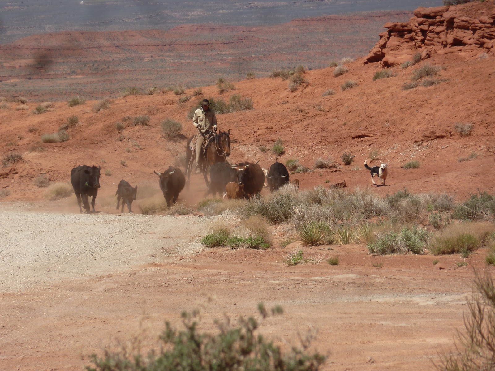
Real cowboys still exist.
Started in the morning with clouds, and rain in the
far the distance. But haven't seen a drop myself.
More than 1 hour drive, just to get to the first next
town: "Bluff". They have an amazingly good open
air museum, with displays how the Mormons opened
the route "Hole in the Rock". Bought the book
with that name by David Miller. It describes
how about 200 people in 1879 created the most
difficult passage on the Colorado river, to get
to the San Juan River.
And when you see the landscape, and think about
the first settlers, you are more and more
impressed.
Then up to the sight seeing. Yes, started with
the "Valley of the Gods" road. And off-road 17
mile drive. between the rocks, similar as monument
valley.
And yes the cowboy was guiding his cows in the
"Valley of the Gods". Coincidence ?
Up to Gooseneck state reserve. Ever seen a river,
here the San Juan, which really meanders....
The google satellite shows this even more
impressive. Search this in google maps, and
select satelite:
"Goosenecks State Park, San Juan, UT"
Or click the link below (if this works).
Gooseneck
And then, up another plateau. Literally:
Arrived in the late afternoon, in 'Natural Bridges'.
Campground totally full. But they showed me a place
for 'dispersed wilderness camping'. That was a
quiet night. No one in any direction.
Real cowboys still exist.
Started in the morning with clouds, and rain in the
far the distance. But haven't seen a drop myself.
More than 1 hour drive, just to get to the first next
town: "Bluff". They have an amazingly good open
air museum, with displays how the Mormons opened
the route "Hole in the Rock". Bought the book
with that name by David Miller. It describes
how about 200 people in 1879 created the most
difficult passage on the Colorado river, to get
to the San Juan River.
And when you see the landscape, and think about
the first settlers, you are more and more
impressed.
Then up to the sight seeing. Yes, started with
the "Valley of the Gods" road. And off-road 17
mile drive. between the rocks, similar as monument
valley.
And yes the cowboy was guiding his cows in the
"Valley of the Gods". Coincidence ?
Up to Gooseneck state reserve. Ever seen a river,
here the San Juan, which really meanders....
The google satellite shows this even more
impressive. Search this in google maps, and
select satelite:
"Goosenecks State Park, San Juan, UT"
Or click the link below (if this works).
Gooseneck
And then, up another plateau. Literally:
Arrived in the late afternoon, in 'Natural Bridges'.
Campground totally full. But they showed me a place
for 'dispersed wilderness camping'. That was a
quiet night. No one in any direction.
Monday, April 22, 2013
Mon Apr 22 2013
Still (stuck) in Arizona.
Driving thru the desert.
Visit to Navajo National Monument, with the small
village in the rocks (around 1250): 'Betatakin' Canyon.
And then the 17 mile drive thru monument Valley.
Impressive.
Very windy. Was even afraid to get my camera out in
the beginning. Sand and these cameras don't go together.
But after a while, less wind, more sun.
Really helps, to be really impressed by the magnitude
of the landscape and the rocks.
And some show from one of the many local venders
And just when I wanted to go up north to Utah,
there was a major bomb alarm on a tourist bus,
and all roads (the only one) was totally blocked
by the police. So, stay in the very expensive
hotel in the park, or return 30 miles.
But still part of the huge Navajo Indian Reservation.
And no alcohol. It's bad to be stuck.
Still (stuck) in Arizona.
Driving thru the desert.
Visit to Navajo National Monument, with the small
village in the rocks (around 1250): 'Betatakin' Canyon.
And then the 17 mile drive thru monument Valley.
Impressive.
Very windy. Was even afraid to get my camera out in
the beginning. Sand and these cameras don't go together.
But after a while, less wind, more sun.
Really helps, to be really impressed by the magnitude
of the landscape and the rocks.
And some show from one of the many local venders
And just when I wanted to go up north to Utah,
there was a major bomb alarm on a tourist bus,
and all roads (the only one) was totally blocked
by the police. So, stay in the very expensive
hotel in the park, or return 30 miles.
But still part of the huge Navajo Indian Reservation.
And no alcohol. It's bad to be stuck.
Sunday, April 21, 2013
Sat, Sun Apr 21 2013
Saw the light in the darkness.
Driving from the South rim of the Grand Canyon
(and I won't bore you with 100 additional pictures)
to Page. Somewhere before Page, the road was
closed due to a mayor avalanche. a small detour
of 2 hours brought me over the Navajo bridge, 834 ft
long, 467 high over the Colorado river, Marble Canyon,
the silver cliffs, lake Powell,
and the Glen Canyon Dam.
The Horseshoe Bend is also 'worthwhile'
to stop, if you pass by.
I'm not the only one to enjoy it
But the main thing is the Antelope Canyon.
From the 200 pictures where I saw the light
a few...
You watch deep in the Godzilla Eye
What do you see here ?
By the way, discovered the Damber, a local
beer of DAM BAR, brewed by Lumberyard.
Saw the light in the darkness.
Driving from the South rim of the Grand Canyon
(and I won't bore you with 100 additional pictures)
to Page. Somewhere before Page, the road was
closed due to a mayor avalanche. a small detour
of 2 hours brought me over the Navajo bridge, 834 ft
long, 467 high over the Colorado river, Marble Canyon,
the silver cliffs, lake Powell,
and the Glen Canyon Dam.
The Horseshoe Bend is also 'worthwhile'
to stop, if you pass by.
I'm not the only one to enjoy it
But the main thing is the Antelope Canyon.
From the 200 pictures where I saw the light
a few...
You watch deep in the Godzilla Eye
What do you see here ?
By the way, discovered the Damber, a local
beer of DAM BAR, brewed by Lumberyard.
Saturday, April 20, 2013
Thu Fri Apr 19 2013
Just went to the post office.
I nice lady showed my the way to the post office,
where they stamp the mail "send by mule".
It was a little longer than expected to get there.
More than 3 hours, one way. The office happened to
be in a pub. And after some tasting, it was to
late to return. So, needed to spent the night there.
Good, because it took more than 5 hours to go back.
To the next pub (you know, you have to drink a lot
when hiking, even of the hike is to the post office).
And these guys deliver the mail.
Other part of the story.
Wednesday, I did only the 3 mile point down,
and I passed everyone the way up. The views
where so extreme, that I went to the back country
office to try to get a permit. And miracle: got it
and the last camping spot in 'phantom ranch', just
next to the bridge over the Colorado river.
On one hand cheap, free camping, the permit only 15 $,
but I needed a good backpack, and the ultra light,
high tech jetboil water heater...
The way down was relatively easy. The amazing part
was that I met so many (older people, e.g 72 years
young) who just went down and all the way up again
in the same day.
The way down
And more
And more
And more
And more
Skip a few pictures, but it is still down
And finally the bridge
Was down, just at lunch time, time to visit the
beach, cool my feet in the river, did some local
exploration. And, of coarse, found the local post
office, only served by mules
The post office was also the local pub. Yes, really.
Got several beers, before closing time at 4 PM,
just in time to get a very interesting talk from
the local ranger Emmily, about condors.
After dinner, using my new tool, there was a more
interesting talk from Emmily about failures in the
history of discovery and exploitation of the canyon.
Next morning, the way up. Just amazing. At every corner
the views are totally different. But, also went back
2 billion years in the making of the earth.
At the bottom, you find the "Elvis Chasm Gneiss" rock
which is 1840 million years old. Going up, layer by layer,
you can see more recent rocks. Every step brings you
several million years closer to more recent rock formation.
The last mile up, was somewhat hard. But after a good
Amber in the historically hotel, I was ready to walk
another 3 miles to my car.
Just went to the post office.
I nice lady showed my the way to the post office,
where they stamp the mail "send by mule".
It was a little longer than expected to get there.
More than 3 hours, one way. The office happened to
be in a pub. And after some tasting, it was to
late to return. So, needed to spent the night there.
Good, because it took more than 5 hours to go back.
To the next pub (you know, you have to drink a lot
when hiking, even of the hike is to the post office).
And these guys deliver the mail.
Other part of the story.
Wednesday, I did only the 3 mile point down,
and I passed everyone the way up. The views
where so extreme, that I went to the back country
office to try to get a permit. And miracle: got it
and the last camping spot in 'phantom ranch', just
next to the bridge over the Colorado river.
On one hand cheap, free camping, the permit only 15 $,
but I needed a good backpack, and the ultra light,
high tech jetboil water heater...
The way down was relatively easy. The amazing part
was that I met so many (older people, e.g 72 years
young) who just went down and all the way up again
in the same day.
The way down
And more
And more
And more
And more
Skip a few pictures, but it is still down
And finally the bridge
Was down, just at lunch time, time to visit the
beach, cool my feet in the river, did some local
exploration. And, of coarse, found the local post
office, only served by mules
The post office was also the local pub. Yes, really.
Got several beers, before closing time at 4 PM,
just in time to get a very interesting talk from
the local ranger Emmily, about condors.
After dinner, using my new tool, there was a more
interesting talk from Emmily about failures in the
history of discovery and exploitation of the canyon.
Next morning, the way up. Just amazing. At every corner
the views are totally different. But, also went back
2 billion years in the making of the earth.
At the bottom, you find the "Elvis Chasm Gneiss" rock
which is 1840 million years old. Going up, layer by layer,
you can see more recent rocks. Every step brings you
several million years closer to more recent rock formation.
The last mile up, was somewhat hard. But after a good
Amber in the historically hotel, I was ready to walk
another 3 miles to my car.
Wednesday, April 17, 2013
Wed Apr 17 2013
Arizona = Grand Canyon.
Nice warning:
You are free to go down, but it is mandatory
to come up.
Definitely a micro climate. Have seen snow, small
sand storm and beautiful sunny weather.
Impossible to really capture this on a picture.
Tried so many different angles, but no real success.
Will try harder the next days.
Arizona = Grand Canyon.
Nice warning:
You are free to go down, but it is mandatory
to come up.
Definitely a micro climate. Have seen snow, small
sand storm and beautiful sunny weather.
Impossible to really capture this on a picture.
Tried so many different angles, but no real success.
Will try harder the next days.
Subscribe to:
Posts (Atom)